 |
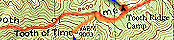
This is what all our routes will look like on the map. The red line is our main path. It marks trails travelled with our packs on. Yellow lines represent side hikes that we took without packs. The red dots indicate camps where we spent the night. |
 |
These blue triangles are the basis of the photo-journal. Clicking on one (with a capable client) will take you to another page with a picture of that point and a journal entry about our trip. |
 |
These red arrows are placed at the edge of maps where the trail runs off the edge. They will take you to the next section of map, or back to the one you just came from. |
 |
Click on this button any time to take you back to the introduction, the photojournal main page. |


